Nohoanga provides all Ngāi Tahu with an opportunity to experience the landscape as their tīpuna did, and to rekindle the traditional practices of gathering food and other natural resources.
The term ‘nohoanga’ (literally meaning a place to sit) traditionally refers to the seasonal occupation sites which were an integral part of the mobile lifestyle of Ngāi Tahu whānui as they moved around Te Waipounamu (the South Island) in pursuit of food and other natural resources.
This traditional concept has been given contemporary effect as a result of the Settlement of the Ngāi Tahu Claim through the allocation of specific ‘camping’ sites to support mahinga kai activities.
Under the Ngāi Tahu Claims Settlement Act 1998, nohoanga sites are specific areas of Crown owned land adjacent to lakeshores or riverbanks, which can be used to facilitate the gathering of food and other natural resources by Ngāi Tahu whānui. They are usually one hectare in size.
Ngāi Tahu whānui (tribal members) have temporary but exclusive rights to occupy these sites between the middle of August and the end of April each year.
There are 72 allocated nohoanga sites within Te Waipounamu. Not all of these sites are available for use. Please contact 0800 NOHOANGA (0800 664 62642), [email protected]; or visit our website www.ngaitahu.iwi.nz for more information.
Procedure for Use of Nohoanga
Nohoanga are for the exclusive use of Ngäi Tahu whānui. For fairness and environmental reasons, the use of nohoanga sites is by authorisation only, and administered by Te Rūnanga o Ngāi Tahu. See below for procedure for authorisation.
Contact Sophie McGregor on 0800 nohoanga (0800 664-62642) or [email protected] at least 10 working days before you wish to use a nohoanga site. Provide basic details (name, address, contact numbers, vehicle registration number, and number of people you wish to take etc).
NB – random checks will be done to ensure both those applying for authorisation are entitled to do so, and that past use has been consistent with the conditions of the authorisation. If the site is available you will be sent an authorisation (by post, fax or email) before you leave for the nohoanga site;
Return the authorisation back to us within 10 days (signed and with the relevant sections completed) following your departure from the nohoanga site.
Available for use – Waikaia River (Piano Flat), Southland
Location
This nohoanga site is situated about one and a half hours drive north-west of Gore Township.
From State Highway 94, turn off at Riversdale-Waikaia Road and travel north past Waikaia township, past Glenary Station and into the Waikaia (Piano Flat) recreation area.
The nohoanga site is situated on the right hand side of the road and backs onto the last private hut in the recreational area. Directly across the road from the nohoanga is a Department of Conservation camping area and further up the road is a childrens play area.
Physical description
The nohoanga is situated on a hill overlooking the Waikaia River just off the Waikaia road. The site is mostly sloped, with steeper slopes towards the back of the site. There are a few flat areas for camping.
The nohoanga is covered in grass and is well sheltered by beech forest. The site is situated beside a private hut. This nohoanga site has excellent two wheel drive vehicle access to the site.
Access onto the site itself is by foot only, therefore the site would be unsuitable for caravans or campervans.
Nohoanga site users can park their vehicles on the flat area, immediately adjacent to the site. Such parking shall not inhibit access for other members of the public or be parked in an obvious camping site.
Facilities and services
Nohoanga site users have permission to use the nearby public water supply, which runs continuously into a basin approximately 100m away from the site. Users cannot, however, tap either the water race or pipes carrying the water. Nohoanga users may use the nearby public toilet facilities.
A park bench is located in close proximity to the site, across the other side of the Waikaia Road. The site has a large field nearby and a children’s play area with swings and slides etc. There is no cell phone reception. All rubbish and waste must be removed by users before departing Waikaia River (Piano Flat) nohoanga.
There are numerous old shafts associated with gold mining/prospecting throughout the wider area of the Waikaia River (Piano Flat) nohoanga site. There are known shafts up behind the nohoanga site, adjacent to the public access walk. Caution and care needs to be taken when walking around the bush area.
The Waikaia River is subject to flooding in high rainfall events and nature of the terrain is such that the river can rise quite suddenly. During high rain fall road access could be impeded to and from the Waikaia River (Piano Flat) nohoanga site.
Site restrictions
Fire restrictions may apply to this area. Please contact the DoC area office in Invercargill to assess the situation before using this site. Comprehensive information on fire control in this area is available via the Southern Rural Fire Authority website: www.southernruralfire.org.nz
Dogs must be on a leash on public roads at all times. Owners must also ensure dogs do not worry stock or other campers both on the nohoanga site and adjacent public camping site.
Those wishing to hunt in the area require a hunting permit from DoC. Firearms should not be carried without a valid hunting permit. Please see the DoC website for information about hunting and firearm safety.
Note: by using the Waikaia (Piano Flat) nohoanga site you are agreeing to these conditions.
Please ring 0800 NOHOANGA (0800 664 62642), [email protected], or visit our website www.ngaitahu.iwi.nz for more information about Waikaia River (Piano Flat) and any other nohoanga.
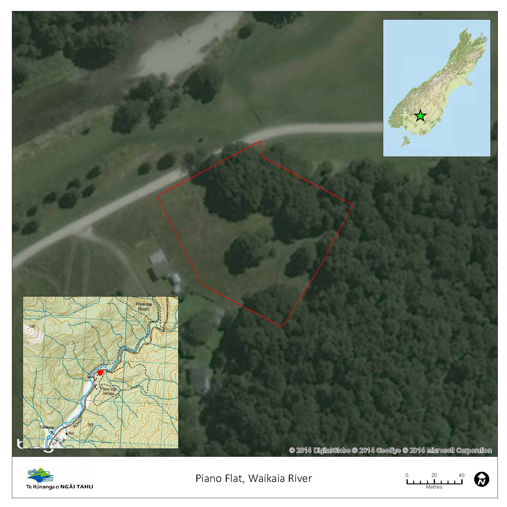
The Waikaia (Piano Flat) nohoanga site.
Waipara River (Township) – North Canterbury
Location
The Waipara nohoanga site is situated approximately one hour north of Christchurch. Travelling north on State Highway 1, turn off at Waipara Township onto SH7 (the inland route to Hanmer Springs), travel about half a kilometre and turn left into Barnett’s Road. The site is at the end of Barnett’s Road in amongst the willows.
Physical description
The nohoanga is situated beside the Waipara River. The site is large, flat and well sheltered, providing an excellent camping area. It has excellent vehicle access and is suitable for both caravans and campervans. There are numerous vehicle tracks through the site and plenty of space for parking vehicles.
Facilities and services
This site has no facilities or services. Nohoanga site users will be required to hire portable toilets and are required to bring their own water supplies (a minimum of 10 litres per day for every person on the site). All rubbish and waste must be removed by users before leaving the site. See key contacts below for details of refuse and dumping stations.
Site restrictions
Fire restrictions may apply to this area. Please contact the Hurunui District Council before using this site to assess the situation. Note: by using Waipara River (Township) nohoanga site you are agreeing to these conditions.
Please ring 0800 NOHOANGA (0800 66462642), [email protected], or visit our website www.ngaitahu.iwi.nz for more information about the Waipara nohoanga site.
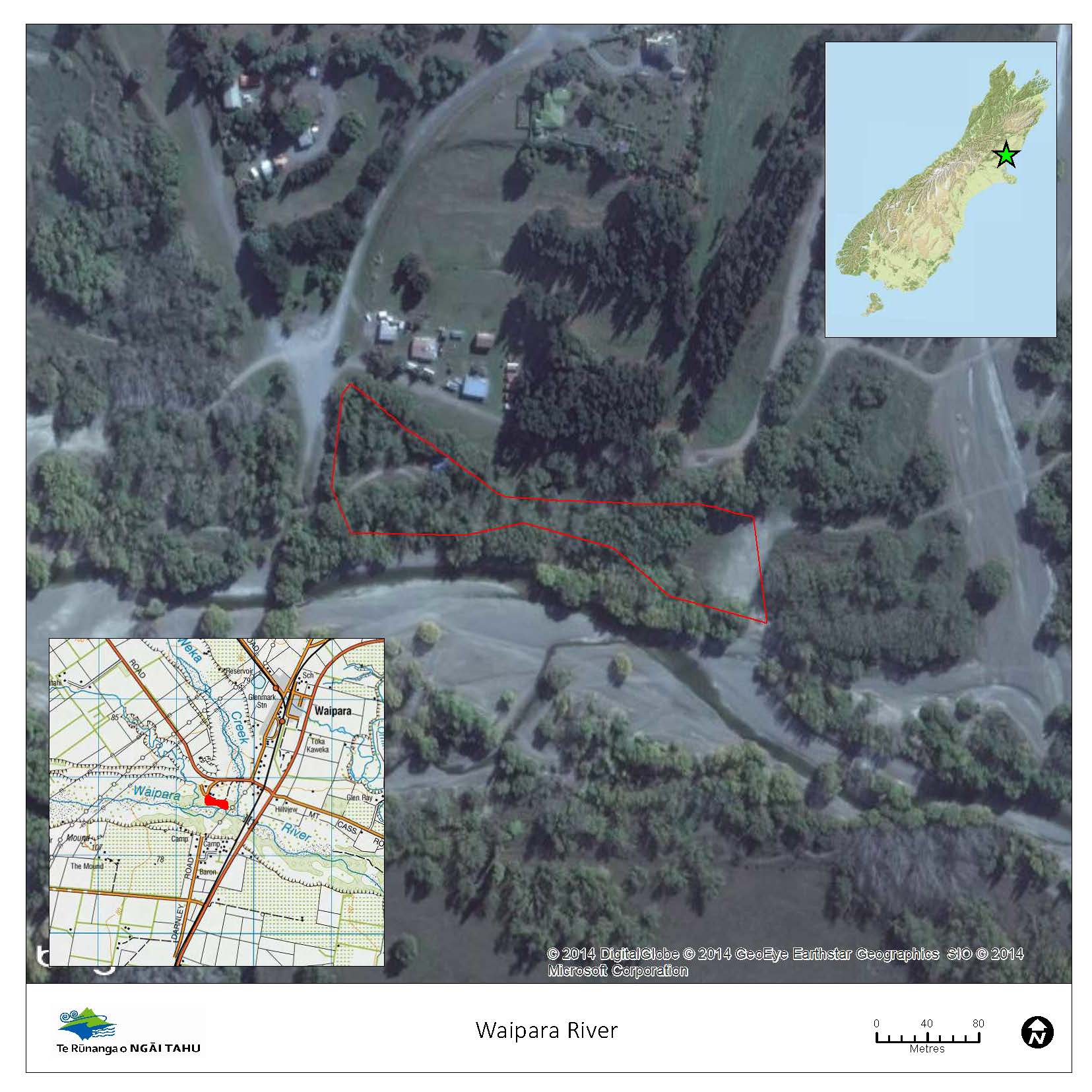
The Waipara River (Township) nohoanga site.